


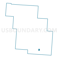
HEMLOCK Voting District, Perry County, Ohio
About
Outline

Summary
| Unique Area Identifier | 650940 |
| Name | HEMLOCK Voting District |
| County | Perry County |
| State | Ohio |
| Area (square miles) | 0.37 |
| Land Area (square miles) | 0.37 |
| Water Area (square miles) | 0.00 |
| % of Land Area | 99.37 |
| % of Water Area | 0.63 |
| Latitude of the Internal Point | 39.59254360 |
| Longtitude of the Internal Point | -82.15235410 |
Maps

Graphs
Select a template below for downloading or customizing gragh for HEMLOCK Voting District, Perry County, Ohio


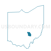
Neighbors
Neighoring Voting District (by Name) Neighboring Voting District on the Map
- COAL Voting District, Perry County, OH
- MONROE Voting District, Perry County, OH
- SALTLICK Voting District, Perry County, OH
Top 10 Neighboring County Subdivision (by Population) Neighboring County Subdivision on the Map
- Monroe township, Perry County, OH (1,508)
- Salt Lick township, Perry County, OH (1,262)
- Coal township, Perry County, OH (1,042)